إكتشاف مدينه إرم

تقليص

عن الكاتب

تقليص

شباب روش طحن اكتشف المزيد حول شباب روش طحن
X
 
  • تصفية - فلترة
  • الوقت
  • عرض
إلغاء تحديد الكل
مشاركات جديدة

  • إكتشاف مدينه إرم

    قال تعالى
    ( وَاذْكُرْ أَخَا عَادٍ إِذْ أَنْذَرَ قَوْمَهُ بِالْأَحْقَافِ وَقَدْ خَلَتِ النُّذُرُ مِنْ بَيْنِ يَدَيْهِ وَمِنْ خَلْفِهِ أَلَّا تَعْبُدُوا إِلَّا اللَّهَ إِنِّي أَخَافُ عَلَيْكُمْ عَذَابَ يَوْمٍ عَظِيمٍ) (الاحقاف)


    لقد أخبر القرآن الكريم أن قوم عاد بنوا مدينة اسمها ( إرم ) ووصفها القرآن بأنها كانت مدينة عظيمة لا نظير لها في تلك البلاد

    قال تعالى
    أَلَمْ تَرَ كَيْفَ فَعَلَ رَبُّكَ بِعَادٍ{6} إِرَمَ ذَاتِ الْعِمَادِ {7} الَّتِي لَمْ يُخْلَقْ مِثْلُهَا فِي الْبِلَادِ {8} (سورة الفجر)

    وقد ذكر المؤرخون أن عاداً عبدوا أصناماً ثلاثة يقال لأحدها : صداء وللأخر : صمود ، وللثالث : الهباء وذلك نقلاً عن تاريخ الطبري.

    ولقد دعا هود قومه إلى عبادة الله تعالى وحده وترك عبادة الأصنام لأن ذلك سبيل العذاب يوم القيامة .

    ولكن ماذا كان تأثير هذه الدعوة على قبيلة ( عاد ) ؟

    لقد احتقروا هوداً ووصفوه بالسفه والطيش والكذب ، ولكن هوداً نفى هذه الصفات عن نفسه مؤكداً لهم أنه رسول من رب العالمين لا يريد لهم غير النصح كما هو حال جميع الأنبياء عندما يواجهوا العناد من قومهم

    أهم النقاط التي تطرق القرآن لذكرها في قصة هود :

    1 - قوم هود كانوا يسكنون في الأحقاف وهي الأرض الرملية ولقد حددها المؤرخون بين اليمن وعمان

    2- أنه كان لقوم عاد بساتين وأنعام وينابيع قال تعالى وَاتَّقُوا الَّذِي أَمَدَّكُم بِمَا تَعْلَمُونَ {132} أَمَدَّكُم بِأَنْعَامٍ وَبَنِينَ {133}وَجَنَّاتٍ وَعُيُونٍ

    3. أن قوم عاد بنوا مدينة عظيمة تسمى إرم ذات قصور شاهقة لها أعمدة ضخمة لا نظير لها في تلك البلاد لذلك قال تعالى ( ألم ترى كيف فعل ربك بعاد إرم ذات العماد، التي لم يخلق مثلها في البلاد).

    4. إنهم كانوا يبنون القصور المترفة والصروح الشاهقة (أتبنون بكل ريع ٍ آية تعبثون، وتتخذون مصانع لعلكم تخلدون).

    5- لما كذبوا هوداً أرسل عليهم الله تعالى ريحاً شديدة محملة بالأتربة قضت عليهم وغمرت دولتهم بالرمال
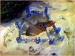
    الاكتشافات الأثرية لمدينة إرم


    فى بداية عام 1990امتلأت الجرائد العالمية الكبرى بتقاريرصحفية تعلن عن: " اكتشاف مدينة عربية خرافية مفقودة " ," اكتشاف مدينة عربية أسطورية " ," أسطورة الرمال (عبار)", والأمر الذي جعل ذلك الاكتشاف مثيراً للاهتمام هو الإشارة إلى تلك المدينة في القرآن الكريم. ومنذ ذلك الحين, فإن العديد من الناس؛ الذين كانوا يعتقدون أن "عاداً" التي روى عنها القرآن الكريم أسطورة وأنه لا يمكن اكتشاف مكانها، لم يستطيعوا إخفاء دهشتهم أمام اكتشاف تلك المدينة التي لم تُذكر إلا على ألسنة البدو قد أثار اهتماماً وفضولاً كبيرين

    منذ اللحظة التي بدأت فيها بقايا المدينة في الظهور, كان من الواضح أن تلك المدينة المحطمة تنتمي لقوم "عاد" ولعماد مدينة "إرَم" التي ذُكرت في القرآن الكريم؛ حيث أن الأعمدة الضخمة التي أشار إليها القرآن بوجه خاص كانت من ضمن الأبنية التي كشفت عنها

    قال د. زارينزوهو أحد أعضاء فريق البحث و قائد عملية الحفر, إنه بما أن الأعمدة الضخمة تُعد من العلامات المميزة لمدينة "عُبار", وحيث أن مدينة "إرَم" وُصفت في القرآن بأنها ذات العماد أي الأعمدة الضخمة, فإن ذلك يعد خير دليل على أن المدينة التي اكتُشفت هي مدينة "إرَم" التي
    ذكرت في القرآن الكريم

    قال تعالى في سورة الفجر :
    " أَلَمْ تَرَ كَيْفَ فَعَلَ رَبُّكَ بِعَادْ (6) إِرَمَ ذَاتِ العِمَادْ (7) الَّتِى لَمْ يُخْلَقْ مِثْلُهَا فِى البِلادْ(8)"

    المدينة الأسطورية والتي ذكرت في القرآن باسم إرم أنشأت لِكي تَكُونَ فريدةَ جداً حيث تبدو مستديرة ويمر بها رواق معمّد دائري، بينما كُلّ المواقع الأخرى في اليمن حتى الآن كَانتْ التي اكتشفت كانت أبنيتها ذات أعمدة مربعة يُقالُ بأن سكان مدينة أرم بَنوا العديد مِنْ الأعمدةِ التي غطيت بالذهبِ أَو صَنعتْ من الفضةِ وكانت هذه الأعمدةِ رائعة المنظر "

    قال تعالى على لسان نبي الله هود:" أتبنون بكل ريع ٍ آية تعبثون، وتتخذون مصانع لعلكم تخلدون، وإذا بطشتم بطشتم جبارين، فأتقوا الله واطيعون. واتقوا الذي أمدكم بما تعلمون، أمدكم بأنعام وبنين وجنات وعيون ، إني أخاف عليكم عذاب يوم عظيم" الشعراء

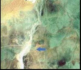
    ولقد كشفت السجلات التاريخية أن هذه المنطقة تعرضت إلى تغيرات مناخية حولتها إلى صحارى، والتي كَانتْ قبل ذلك أراضي خصبة مُنْتِجةَ فقد كانت مساحات واسعة مِنْ المنطقةِ مغطاة بالخضرة كما أُخبر القرآنِ، قبل ألف أربعمائة سنة حينما كان يعيش بها قوم عاد ولقد كَشفَت صور الأقمار الصناعية التي ألتقطها أحد الأقمار الصناعية التابعة لوكالة الفضاء الأمريكية ناسا عام 1990 عن نظامَ واسع مِنْ القنواتِ والسدودِ القديمةِ التي استعملت في الرَيِّ في منطقة قوم عاد والتي يقدر أنها كانت قادرة على توفير المياه إلى 200000 شخصَ


    كما تم تصوير مجرى لنهرين جافين قرب مساكن قوم عاد أحد الباحثين الذي أجرى أبحاثه في تلك المنطقة قالَ" لقد كانت المناطق التي حول مدنية مأرب خصبة جداً ويعتقد أن المناطق الممتدة بين مأرب وحضرموت كانت كلها مزروعة

    أما سبب اندثار حضارة عاد فقط فسرته أحدي الصحف الفرنسيه* التي ذكرت أن مدينة إرم أو"عُبار" قد تعرضت إلى عاصفة رملية عنيفة أدت إلى غمر المدينة بطبقات من الرمال وصلت سماكتها إلى حوالي 12 متر

    وهذا تماماً هو مصداق لقوله تعالى :
    (فَأَرْسَلْنَا عَلَيْهِمْ رِيحًا صَرْصَرًا فِي أَيَّامٍ نَّحِسَاتٍ لِّنُذِيقَهُم عَذَابَ الْخِزْيِ فِي الْحَيَاةِ الدُّنْيَا وَلَعَذَابُ الْآخِرَةِ أَخْزَى وَهُمْ لَا يُنصَرُونَ)


    * M’Interesse, January 1993

    وهذه مواقع أجنبيه محايده توثق للحقائق العلميه في الموضوع


    http://www.pbs.org/wgbh/nova/ubar/zarins/

    http://observe.arc.nasa.gov/nasa/exhibits/ubar/ubar_0.html


    الموضوع منقول من موقع موسوعه الإعجاز العلمي في القرأن والسنه

    تم تنسيق الموضوع بمعرفتى
    سيف الكلمة
    التعديل الأخير تم بواسطة محمد شبانه; 31 أكت, 2020, 08:18 ص.

  • #2
    Lost City of Arabia
    أصدق وعد الله وأكذب توازنات القوى
    والسماء لا تمطر ذهبا ولا فضـة
    وينصر الله من ينصره

    تعليق


    • #3
      Lost City of Arabia


      The Sky's Eyes:
      Remote Sensing in Archaeology


      Some would argue that the greatest advancement in archaeology since the shovel is remote sensing, or being able to "see" an archaeological site without actually excavating it. (If nothing else, it's certainly easier on the lower back.)

      This type of "seeing" can take place either from the air or the ground. Ground Penetrating Radar (GPR), dubbed "the red sled" on the Ubar dig, is a radar device that, when dragged over a site, can give a rough picture of any structure that may lie beneath. Geophysical Diffraction Tomography (GDT) accomplishes the same thing with sound waves coming from an 8-gauge shotgun. But perhaps the most spectacular remote sensing tools are those that create images of earth from the sky.

      The first known aerial photographs of an archaeological site were taken from a war balloon by Lieutenant P. H. Sharpe in the early 1900s. The target was Stonehenge. In World War I, photographers conducting military reconnaissance flights kept running across sites of archaeological interest. It wasn't long before military officers began actively seeking out such sites on their own. One pioneer was Lieutenant-Colonel G. A. Beazeley, who discovered the extensive outlines of ancient canals in Mesopotamia's Tigris-Euphrates plain. But as useful as aerial photographs are, they have their limitations: namely, airplanes can fly only so high and human eyes can see only so much.

      "Our eyeballs are tuned-up for finding lunch, not for differentiating rocks or terrain," explains Ron Blom of the Jet Propulsion Laboratory, NASA's center for unmanned planetary exploration. "If our eyeballs could see the longer wavelengths on the electromagnetic spectrum, what looks like a red soil to your eye right now would actually turn out to be all sorts of beautiful colors. There's a lot of information out there that our eyes just can't see."

      To solve that problem, scientists designed and launched the first multi-spectral imaging satellite in 1972. Called Landsat-1, the satellite sent back images of an earth no one had ever seen before. Reading visible light, as well as the infrared bands of the electromagnetic spectrum, Landsat revealed a psychedelic world of magenta vegetation, black water and gold forests. It also showed pollution off the coast of New Jersey, unmapped lakes in Iran and additional branches of the San Andreas fault. "Rocks, soils and vegetation look different at these longer wavelengths," explains Bloom. "And because a lot of materials appear more contrasty at longer wavelengths, they're easier to isolate and detect."

      Archaeologists didn't appreciate the full potential of space imaging until 1981, when NASA launched an imaging system called SIR-A on the Space Shuttle. Unlike Landsat 1, which used reflected sunlight to make an image, SIR-A sent out its own radar signal and then "listened" to the echo. Archeologist Farouk El-Baz, now director of the Center for Remote Sensing at Boston University, had asked NASA to fly SIR-A over the eastern Sahara desert, hoping it could make sense of the anomalous rock formations he had been studying there. No one was quite prepared for the images that came back.

      The Sahara is the driest place on earth right now, but SIR-A was able to penetrate the sand and reveal an ancient landscape below that, amazingly, had been carved by running water. "The Sahara once looked like the landscape of Europe," El-Baz reported, "with rivers, lakes, mountains and valleys." The banks of the old rivers beds, dubbed "radar rivers" by researchers, turned out to be excellent sites for archaeological excavation, yielding a bevy of Paleolithic tools and artifacts.

      http://www.pbs.org/wgbh/nova/ubar/tools/index.html
      التعديل الأخير تم بواسطة محمد شبانه; 31 أكت, 2020, 08:17 ص.
      أصدق وعد الله وأكذب توازنات القوى
      والسماء لا تمطر ذهبا ولا فضـة
      وينصر الله من ينصره

      تعليق


      • #4


        When news of SIR-A's x-ray like abilities reached the news media, phones started ringing off the hook at NASA's Jet Propulsion Lab. "We started getting calls from people saying, 'I know where Atlantis is,' and, 'If you guys give me the data, I'll find my Grandmother's buried treasure,' and so on," laughs Ron Blom. "What people didn't realize was that the radar could only penetrate about 10-15 feet and could only accomplish this through exceedingly dry and fine-grained material -- like desert sand." Even so, SIR-A demonstrated the enormous power of space-borne imaging for archaeologists.

        In recent years, the technology has only become more sophisticated. There are now five Landsat satellites orbiting the earth (not to mention the numerous imaging satellites belonging to other countries in orbit). Landsat 4 and Landsat 5 are equipped with something called "Thematic Mapper," which can radio seven channels of digital data back to earth -- three in the visible spectrum, three in the reflective infrared spectrum and one in the thermal infrared spectrum. This multi-spectral data, especially when enhanced by computer processing, can detect the slightest variations in the earth's surface -- like the trail leading to the Ubar site. "The surface material of the incense trail basically had fewer rocks, more sand, and more dust than the surrounding desert," explains Ron Bloom. "That, maybe along with a couple thousand years of camel dung, stood out extremely well at the longer wavelengths."

        Radar imaging has also undergone a dramatic technological advance. SIR-A was a single-band radar while SIR-C, which flew twice in 1994, is a multi-wavelength radar. Its particular strength is detecting subtle differences in the earth's topography and penetrating some surface materials, especially sand, leaves and ice. One of SIR-C's recent targets was the ancient city of Angkor in Cambodia. The radar's longest wavelengths were able to partially penetrate the dense jungle vegetation and pick up details of the topography hidden below. As a result, researchers were able to identify water reservoirs and moats around the temple complexes that hadn't been visible from the ground. Similarly, recent radar images of the Great Wall of China found an earlier piece of the Wall -- long suspected to have existed, but never located -- buried under dirt and sand.

        Experts are quick to warn that remote sensing, though extremely useful in some cases, is not a silver bullet. "The Ubar site was found by a combination of historical research, remote sensing data and a lot of hard work by guys like Juris Zarins," stresses Ron Bloom.

        Zarins agrees with Blom, but is clearly a fan of the new technology. "Remote sensing allows you to get a picture of the terrain you otherwise wouldn't see. It gives you a better feel for what the terrain is like and where the possibility of finding sites are. And when it's put together with GPS (Global Positioning System) and you're able to tell an automobile driver or a helicopter pilot, 'Go to this site at these coordinates,' and they can drop you right off there, it's very very helpful."


        http://www.pbs.org/wgbh/nova/ubar/tools/tools2.html
        أصدق وعد الله وأكذب توازنات القوى
        والسماء لا تمطر ذهبا ولا فضـة
        وينصر الله من ينصره

        تعليق


        • #5
          Interview with Dr. Juris Zarins
          September 1996


          NOVA: Have you been back to Shisur since the time of our filming?

          JZ: Yeah, we put in two-and-a-half more years of excavation at the site.

          NOVA: Are you still confident that you found Ubar?

          JZ: There's a lot of confusion about that word. If you look at the classical texts and the Arab historical sources, Ubar refers to a region and a group of people, not to a specific town. People always overlook that. It's very clear on Ptolomy's second century map of the area. It says in big letters "Iobaritae" And in his text that accompanied the maps, he's very clear about that. It was only the late Medieval version of The One Thousand and One Nights, in the fourteenth or fifteenth century, that romanticized Ubar and turned it into a city, rather than a region or a people.

          NOVA: Then what did you find?

          JZ: Well, there was a tribal group of people, the Iobaritae or the Ubarites, who lived in the area, and the Shisur site is one of probably three or four major centers from that period. It was a key site with regard to the trade that was coming and going along the edge of the great Empty Quarter. And it's one of those major sites with water. So, there was a lost city of Ubar and we did find it!

          NOVA: What were the most interesting artifacts that you found at the Shisur site?

          JZ: I think the most interesting artifacts were the "red polish" pottery wares. My previous work had been in northern and central Arabia, so we weren't familiar with this style of pottery. When we first found it, we thought it was kind of Roman-like, but we soon got our bearings and realized that the pottery showed a clear Parthian influence.

          NOVA: Does this means the Ubarites were Parthian?

          JZ: No, it just mean that the Parthians were one of their clients. The Parthians were contemporaries of the Ubarites and dominated what is today northern Oman from across Mesopotamia and Iran -- and they also exerted some influence on northwest India, as well. We were surprised to find this Parthian pottery at the Shisur site because, originally, we thought that the Ubarites would be allied with the West. But upon excavation, it looks like most of the pottery wares have an eastern orientation.

          NOVA: What's the significance of this?

          JZ: Traditionally speaking, most people think of the Roman and Greek influence as coming from the south Arabian city states. And this western influence is what's been assumed to have controlled the incense trade, because the west is where most of our historical sources come from. But when we got down to the nitty gritty and actually excavated and surveyed, we discovered that assumption was erroneous. You kind of have to see Arabia as a buffer zone -- half of Arabia belongs to the west and half of Arabia belongs to the east. And, in fact, Mesopotamia goes right down the middle. The Romans never conquered the Parthians, and so the dividing line between the Roman empire was right there.

          http://www.pbs.org/wgbh/nova/ubar/zarins/index.html
          أصدق وعد الله وأكذب توازنات القوى
          والسماء لا تمطر ذهبا ولا فضـة
          وينصر الله من ينصره

          تعليق


          • #6
            NOVA: Does the pottery tell you anything about how the Ubarites lived?

            JZ: Well, we know how they lived from day to day because we've got the bones and vegetable remains that have been analyzed by the people at the British Museum of Natural History. But the interesting part is they seem to have had an outpost out here that tied in a whole network of outposts that linked together a region -- either trading in Frankincense and Myrrh or trading in Arab horses -- all of them seemed to be good candidates. We hadn't suspected that.

            NOVA: They traded in horses too?

            JZ: Later on in medieval times, there are accounts that say that they continued to trade horses out of this region onto the coast and then shipped them to India. And since we do have this link now with India on this pottery, it seems to be that maybe that's one of the other products that they traded out of here.

            NOVA: Did you find storage vats for the frankincense at Shisur?

            JZ: We didn't find vats at Shisur. But we actually found pieces of frankincense -- little crystalline forms. The vats were found at another site further to the east. So there definitely were storage facilities in this region.

            NOVA: Can you tell us more about the satellite campsites around the town?

            JZ: At the time of Ubar, you had nomadic groups moving across the region in the form of caravans. Remember, this is pretty remote out here in terms of water resources. So the caravans are traveling from station to station. The site that we uncovered at Shisur was a kind of fortress/administration center set up to protect the water supply from raiding Bedouin tribes. Surrounding the site, as far as six miles away, were smaller villages, which served as small-scale encampments for the caravans. An interesting parallel to this are the fortified water holes in the Eastern Desert of Egypt from Roman times. There, they were called "hydreumata." Steve Sidebotham of the University of Delaware and Sharon Hebert have done work on this.

            NOVA: What do you make of the thick walls and towers at the Shisur site? Do they indicate that this was a hostile environment?

            JZ: Thick walls and towers are generally put in place because of a hostile environment. We know from present day activity that any permanent source of water is always under threat in the desert. Plus they would have had money in there, because they were conducting trade in frankincense and what have you. And so there was always a temptation to rob people.

            NOVA: What evidence did you find of the practice of agriculture at the Shisur site?

            JZ: We recovered the bones of domestic animals -- cattle, for example. Even, and I hate to say this, pig (laughs) -- of course, absolutely outlawed today -- sheep and goats -- fish brought in from the Indian ocean. And then we got indirect evidence by finding grinding stones for plants like barley and dates, which are traditional to the area.

            NOVA: How could they have grown anything?

            JZ: They had the water, which went out into an irrigation scheme. When Bertram Thomas came through there in the 30's and Thesiger in 40's, he remarked upon the presence of faint field lines, which are now destroyed as a result of modern activity.

            NOVA: Why did such an amazing site remain undetected for so many years?

            JZ: Well, the site had just almost completely disappeared under dirt and rock and sand. So, for years, people used to say well there's nothing there but a little tiny observation post that was put in there about 200 years ago. People wrote it off and said there's nothing there.

            NOVA: Were the pottery shards the clue that led you to believe this might not be the case?

            JZ: Yeah. We began to walk around there and find pottery shards that were definitely not Islamic in date. So, to me, it indicated that the site was either classical or Iron Age or something. Something different.

            NOVA: What are the challenges of pulling off an archaeological dig in the middle of the Omani desert?

            JZ: Logistics are the biggest problem. The idea that you have to bring people out there. They need somewhere to stay. You have to feed them. Fortunately, the Bedouins, with the help of the government of Oman, provided us access to some of the new houses that they had built out there, so we actually were able to stay on site. Our food, however, came from an hour or two away, depending on where we went.
            أصدق وعد الله وأكذب توازنات القوى
            والسماء لا تمطر ذهبا ولا فضـة
            وينصر الله من ينصره

            تعليق


            • #7
              NOVA: Does the pottery tell you anything about how the Ubarites lived?

              JZ: Well, we know how they lived from day to day because we've got the bones and vegetable remains that have been analyzed by the people at the British Museum of Natural History. But the interesting part is they seem to have had an outpost out here that tied in a whole network of outposts that linked together a region -- either trading in Frankincense and Myrrh or trading in Arab horses -- all of them seemed to be good candidates. We hadn't suspected that.

              NOVA: They traded in horses too?

              JZ: Later on in medieval times, there are accounts that say that they continued to trade horses out of this region onto the coast and then shipped them to India. And since we do have this link now with India on this pottery, it seems to be that maybe that's one of the other products that they traded out of here.

              NOVA: Did you find storage vats for the frankincense at Shisur?

              JZ: We didn't find vats at Shisur. But we actually found pieces of frankincense -- little crystalline forms. The vats were found at another site further to the east. So there definitely were storage facilities in this region.

              NOVA: Can you tell us more about the satellite campsites around the town?

              JZ: At the time of Ubar, you had nomadic groups moving across the region in the form of caravans. Remember, this is pretty remote out here in terms of water resources. So the caravans are traveling from station to station. The site that we uncovered at Shisur was a kind of fortress/administration center set up to protect the water supply from raiding Bedouin tribes. Surrounding the site, as far as six miles away, were smaller villages, which served as small-scale encampments for the caravans. An interesting parallel to this are the fortified water holes in the Eastern Desert of Egypt from Roman times. There, they were called "hydreumata." Steve Sidebotham of the University of Delaware and Sharon Hebert have done work on this.

              NOVA: What do you make of the thick walls and towers at the Shisur site? Do they indicate that this was a hostile environment?

              JZ: Thick walls and towers are generally put in place because of a hostile environment. We know from present day activity that any permanent source of water is always under threat in the desert. Plus they would have had money in there, because they were conducting trade in frankincense and what have you. And so there was always a temptation to rob people.

              NOVA: What evidence did you find of the practice of agriculture at the Shisur site?

              JZ: We recovered the bones of domestic animals -- cattle, for example. Even, and I hate to say this, pig (laughs) -- of course, absolutely outlawed today -- sheep and goats -- fish brought in from the Indian ocean. And then we got indirect evidence by finding grinding stones for plants like barley and dates, which are traditional to the area.

              NOVA: How could they have grown anything?

              JZ: They had the water, which went out into an irrigation scheme. When Bertram Thomas came through there in the 30's and Thesiger in 40's, he remarked upon the presence of faint field lines, which are now destroyed as a result of modern activity.

              NOVA: Why did such an amazing site remain undetected for so many years?

              JZ: Well, the site had just almost completely disappeared under dirt and rock and sand. So, for years, people used to say well there's nothing there but a little tiny observation post that was put in there about 200 years ago. People wrote it off and said there's nothing there.

              NOVA: Were the pottery shards the clue that led you to believe this might not be the case?

              JZ: Yeah. We began to walk around there and find pottery shards that were definitely not Islamic in date. So, to me, it indicated that the site was either classical or Iron Age or something. Something different.

              NOVA: What are the challenges of pulling off an archaeological dig in the middle of the Omani desert?

              JZ: Logistics are the biggest problem. The idea that you have to bring people out there. They need somewhere to stay. You have to feed them. Fortunately, the Bedouins, with the help of the government of Oman, provided us access to some of the new houses that they had built out there, so we actually were able to stay on site. Our food, however, came from an hour or two away, depending on where we went.

              http://www.pbs.org/wgbh/nova/ubar/zarins/zarins2.html
              أصدق وعد الله وأكذب توازنات القوى
              والسماء لا تمطر ذهبا ولا فضـة
              وينصر الله من ينصره

              تعليق


              • #8
                NOVA: You shopped daily?

                JZ: No, once a week. We would go to little vegetable markets and we'd pick up bread and vegetables and sometimes frozen meats -- that kind of thing.

                NOVA: Any adventures with spiders or snakes?

                JZ: Not really. A carpet viper did make its way into one of our supply tents and there were camel spiders all around -- but, you know, when you start making noise and banging things around, they pretty much stay away.

                NOVA: What was your favorite part of the expedition?

                JZ: The most wonderful aspect of this is how remote it is from civilization. It's way out there in the desert. And there are beautiful sunsets. There are huge sand dunes and the Empty Quarter isn't far away and the Bedouin are very friendly. They were very hospitable and we'd get to sit around and drink a lot of coffee. It's a very romantic type of atmosphere. At night you can see all the stars. People used to bring telescopes. You could see the moons of Jupiter with binoculars -- it was so clear. And when they'd turn the generator off, it was total silence. No one had ever experienced that kind of silence before. No cars, no people, no television, no electricity, no airplanes going overhead -- none of that.

                NOVA: What did the local people think of what you were doing?

                JZ: Well, at first they were kind of suspicious. They didn't know what the heck archaeology was. But we got several people really interested and they actually started finding sites for us. Once they knew what we were after -- we would train them -- they would go out there and find sites for us. They became really interested.

                NOVA: Has Shisur become something of a tourist destination?

                JZ: Oh yeah. There are people there all the time from all over the world. Journalists, TV people, ordinary tourists. I heard they're going to put up a little hotel there and even a gas station. It's really incredible.

                NOVA: You used a lot of high-tech tools on this expedition. What, in your opinion, are the most important new tools available to archaeologists?

                JZ: Brains! (laughs) No, new tools are great, but they're just that -- tools. You have to be able to understand new tools and how they might help you. But you also need old tools, like ancient manuscripts, the study of geology, the study of climate, the study of plants and animals and all that stuff. It's what we call the interdisciplinary approach to trying to figure out what ancient people did or didn't do.

                NOVA: What's next?

                JZ: Well, I'm actually going to Yemen in January. There are sites there that we suspect were also controlled by the Ubarites -- which we think may have similar kinds of fortresses and buildings. Ron Blom is doing more remote sensing for us. And we've already got some of the images. We're going to try to find precisely how well these cities stand out, if there are water sources associated with them, if the springs are perennial, and if they have these ancient trade routes running across them -- because we know there were routes running across there during medieval times. Now it's just a matter of getting out there and finding the ancient ones.

                http://www.pbs.org/wgbh/nova/ubar/zarins/zarins3.html
                أصدق وعد الله وأكذب توازنات القوى
                والسماء لا تمطر ذهبا ولا فضـة
                وينصر الله من ينصره

                تعليق


                • #9
                  Location of Ubar, Lost City of Arabia


                  http://www.pbs.org/wgbh/nova/ubar/map/index.html
                  أصدق وعد الله وأكذب توازنات القوى
                  والسماء لا تمطر ذهبا ولا فضـة
                  وينصر الله من ينصره

                  تعليق


                  • #10
                    Lost City of Arabia"
                    PBS Airdate: October 8, 1996
                    Go to the companion Web site
                    ANNOUNCER: Tonight on NOVA, the search for a legendary city in an endless desert. A quest to understand a forgotten people. Tantalizing clues of long drawn adventures to seek out the ancient city, Ubar. Now, a new team of archaeologists takes up the challenge. Will they at last discover "The Lost City of Arabia"?
                    NOVA is funded by Prudential.
                    Prudential. Insurance, health care, real estate, and financial services. For more than a century, bringing strength and stability to America's families.
                    And by Merck. Merck. Pharmaceutical research. Dedicated to preventing disease and improving health. Merck. Committed to bringing out the best in medicine.
                    The Corporation for Public Broadcasting. And viewers like you.
                    STACY KEACH: For centuries, the Rub al Khali desert of southern Arabia has kept its secrets, hidden beneath dunes a thousand feet high. It is said that when God divided the world into the sea and the settled lands, He left this as "The Empty Quarter"—uninhabitable, forbidding, unknown. And yet, it is also said that a fabulous city called Ubar once thrived here, only to be swallowed up by the dunes. If Ubar was real, it owed its existence to the incense trade. Camel caravans and ships carried balsam, myrrh, and frankincense for hundreds or thousands of miles, centuries before Christ. Even today, the most precious cargo of the ancient caravans is still being harvested by hand in Oman. A gift suitable for the Queen of Sheba and celebrated in the story of Three Wise Men—the finest frankincense in all the world. Although the trees look like scrub, their resin was once valued as highly as gold. In Arabic, frankincense is called "luban," or milk. At first white, it hardens quickly into fragrant crystals. So valuable was frankincense that Alexander the Great and the Roman emperors dreamed of conquering this land. In this small Omani village of the Shahra people, the day is still measured by the burning of frankincense. First, hot coals are placed in a burner, then the crystals. The Shahra's unique tongue has been called the "language of the birds." Migrating south from the Mediterranean in ancient times, the Shahra's isolated way of life has been preserved—a glimpse of a nearly vanished past. Says the woman, "Incense is most pleasing to God." But the men chide her for using too much. "Enough woman, enough." For thousands of years, the use of frankincense ranged from the religious to the strictly practical. It was a sacred offering to the gods, burned in sanctuaries and temples. But it was also used to mask the harsh smells of everyday life. Frankincense was also thought to have medicinal powers. Here, it's used to help a child suffering from a cold, with his mother to comfort him. The Shahra still sing their ancient songs in the language of the birds. They declare proudly that they are the direct descendants of people who built a great city in the distant past. Somewhere in the desert along one of the incense roads. If they're right, their song may be the last echo of the fabled lost city of Ubar. When Ubar supposedly disappeared, around 300 A.D., the legend began. According to a 13th century historian, Rashid al-Din, Ubar was a city created as an imitation of paradise. It prospered beyond all measure from the frankincense trade. Ubar was the pride of a prideful king—Shaddad, son of King Ad, grandson of Noah. Great was the splendor of Shaddad's city, with it's sumptuous palace and magnificent gardens—too great in the eyes of a prophet, who decried the king's arrogance and impiety, and the wickedness of his subjects. But the Ubarites were too dissolute to pay heed to the prophet. They were too drunk to hear his words, too licentious to care. And so God punished the people of Ubar with a great wind and a terrible noise from the clouds, which struck them dumb. Then, a voice rang out, "You shall perish!" When morning came, there was nothing to be seen except ruins. From that day on, Ubar belonged to evil creatures, each with a single arm, leg, and eye. And it was written that anyone who ventured near would be driven mad with fear. But the Ubar legend proved irresistible to a handful of explorers like Bertram Thomas of England. Sixty years ago, Thomas set out on a daring journey, and became the first European to cross the Rub al Khali desert. Along the way, he encountered an ancient caravan route over 100 yards wide. As Thomas wrote later, a Bedouin guide called it "the road to Ubar." While Thomas mapped his position, the Bedouin explained that Ubar was a great city. "Our fathers have told us that it existed of old," he said, "a city rich in treasure. It now lies buried beneath the sands, some few days to the north." Short on water, Thomas could not follow the road. But he passed on the information to his friend, T.E. Lawrence: "Lawrence of Arabia." Dressed here in Arab clothing, Lawrence is fourth from the right, standing with hands clasped. A soldier and archaeologist, he had a deep love of Arabian history and culture. Back in England, Lawrence became convinced the remains of Ubar lay in the desert. He called it "the Atlantis of the sands." But before he could return to Arabia, he died in 1935. It wasn't until twenty years later that a major expedition was launched by a young American archaeologist named Wendell Phillips. Hoping to find and follow the road that Bertram Thomas described, Phillips ventured into the Rub al Khali. His expedition of trucks pushed on through the shifting sands, until finally it reached a caravan route with 84 parallel camel tracks. Thomas' road to Ubar, as it must have looked for centuries. But Ubar itself eluded him. The caravan route led into a region of impassable dunes. "From here, I knew we were through," wrote Phillips, "for there is no barrier so great as billowing, immeasurable sands, stretching as far as the eye could see, in cruel and sublime grandeur." Finally, in California, at the Huntington Library, a filmmaker and amateur archeologist named Nicholas Clapp decided to try again. For years, he searched among books, documents, and maps for clues to Ubar's location. Finding the fabled city became his obsession.
                    NICHOLAS CLAPP: This was Arabia. Arabia in the days of the incense trade. And in a way, here was a treasure map. For right where it ought to be, just north of where the finest frankincense was grown is the land of the "Iobarite." That's Latin for Ubarites.
                    STACY KEACH: There were other clues in the library's climate-controlled vaults, tantalizing hints in the Koran, references in the Arabian Nights and Greek and Roman histories, and the works of Islamic geographers. In some books, Ubar was mentioned, but had a different name. Or the Ubarites were called "the People of Ad." But nothing gave Ubar's exact location, or proved it was real. Instead, it was the latest in space technology that provided the breakthrough. NASA scientists, intrigued with the Ubar story, agreed to alter the space shuttle's flight plan. For 95 orbits around the Earth, the astronauts performed their usual experiments. But on the 96th orbit, they steered toward the Rub al Khali. A powerful radar signal was beamed to Earth, capable of revealing a hidden past beneath the sand. At NASA's Jet Propulsion Lab, pictures from the shuttle and two satellites were then examined. Known as "false color images," they were enhanced by computers to bring out subtle, geological irregularities.
                    RON BLOM: So, we're looking at a big chunk of country. I think we've got something with this.
                    STACY KEACH: Ron Blom is a NASA geologist.
                    RON BLOM: Yeah, this is false color. This is a Landsat quarter scene, where it's about 90 kilometers across here. The Bertram Thomas road area is up in here at the top.
                    STACY KEACH: It's an ancient lake bed that hints at a greener past.
                    NICHOLAS CLAPP: And what we want to do is go up in here.
                    STACY KEACH: Because caravan roads are beaten down more than surrounding areas, their soil has different reflective properties. By scanning several bands of light, the imaging reveals the roads as gossamer-thin lines.
                    NICHOLAS CLAPP: Any more processing we can do?
                    ROBERT CRIPPEN: I've done an enhancement, couple band ratio where we divide one band by another. What that tends to do is enhance the reflecting properties in some cases. In some cases, they cancel out. So, we'll see what that does for us. Let's see.
                    STACY KEACH: Further processing may tell which roads are relatively new, and which, if any, are ancient. Only when reflected near-infrared light is imaged in color is the answer revealed. Now, only one road remains, the oldest of them all. But is it the road to Ubar?
                    NICHOLAS CLAPPN: Yeah. And we've got a good track all the way up through here.
                    STACY KEACH: The only way to find out for sure is to travel to Oman. A country of one and a half million, Oman gets most of its income now from oil. But there are still people who follow the old ways, and who talk of ancient glory, when frankincense was king and all the world sought it. Although Ubar was thought to be far inland—if anywhere—a new expedition begins on the Omani coast, nearest the incense groves. In ancient days, the Romans called this land "Arabia Felix," or Fortunate Arabia. Not out of admiration for its natural beauty, but out of envy for its wealth. Today, it belongs mostly to the wildlife. Before the team members search for the road to Ubar, they hope to find some trace of its builders: the mysterious People of Ad. They know that two thousand years ago, ships arrived at a port called Moscha from as far away as the Indies, seeking cargoes of frankincense. These ruins are all that remain of a town that guarded the harbor below. No one knows if it's really Moscha, but it does date to the time of Ubar. The expedition team is international—a mix of amateurs and professionals led by Nick Clapp. Ron Blom is chief navigator.
                    NICHOLAS CLAPP: A little closer to the camera here.
                    STACY KEACH: Archaeologist Juris Zarins is an expert on Arabia, while explorer Ran Fiennes, on the right, will handle logistics. Fiennes, like Zarins, isn't sure whether Ubar is a single city, or an entire land. After so many years of planning, the search for Ubar is about to begin. But Ubar's people of Ad prove to be as elusive as Ubar itself. An inscription at some nearby ruins proclaims the site a colonial outpost of another distant kingdom. There is no mention of the People of Ad or Ubar. Hopeful of finding other sites, Juris Zarins and Ran Fiennes explore the coast.
                    JURIS ZARINS: Wait a minute. Slow down a little bit. I see something. They're really quite nice. Want to see those structures over there?
                    RAN FIENNES: Every rock we see, you want to stop!
                    JURIS ZARINS: No, no. Slow down here. These are really important.
                    STACY KEACH: Near an inlet named Khor Soli, they find hundreds of stone structures in an ancient graveyard.
                    JURIS ZARINS: There are tons of these things scattered all over the place—large, huge blocks you see like that. And they're all over out here. You've never found anything yet, right? OK, let's take a look. All right, what have we got?
                    RAN FIENNES: This is a reflection on my instructor.
                    JURIS ZARINS: Now, don't step on that. There's something right there. See that? Look at that. That's pottery. So, what we have here is some of that burnished ware. Now, look at that. See? Hold that in the sun there. Look how it shines. See that?
                    RAN FIENNES: Um hmm.
                    JURIS ZARINS: So, the people who made that pottery took a little stick and they rubbed it real good to give it a shine. They were poor. They couldn't make fancy pottery. So, that kind of technique tells us a lot, because it's not as recent as some of the other pottery. And it's at least from the time of Christ, maybe even a lot earlier.
                    STACY KEACH: The pottery's age and distinctive style lead Zarins to believe it could be the work of the People of Ad. Ubar is thought to have lasted for three thousand years. But when it disappeared, a few centuries after Christ, the People of Ad seemed to vanish with it. Of all the coastal sites the expedition team visited, it was most interested in a place called the "Oracle of Ad." An oracle is an ancient shrine to the gods. But the site is also marked by a great dry well.
                    JURIS ZARINS: Ran, right to your left. Yeah, there you go.
                    STACY KEACH: They find something at the well's ancient water line.
                    JURIS ZARINS: What have we got? Four blocks there?
                    STACY KEACH: It's a cluster of stones which could be the remnants of a platform where the People of Ad filled their jugs with water.
                    JURIS ZARINS: Now, you see by your left foot?
                    RAN FIENNES: Yeah.
                    JURIS ZARINS: Yeah, go to your left, a little bit more to Karl. Yeah, what's that?
                    RAN FIENNES: Wood.
                    JURIS ZARINS: Can you get down to it?
                    STACY KEACH: The wood dates to a period when Ubar had already vanished. But there may be older artifacts down at the bottom.
                    RAN FIENNES: See that ledge just behind you?
                    NICHOLAS CLAPP: You've got about five feet.
                    RAN FIENNES: OK. If we touch it at all, we'll bring the whole lot down. So, you've got to be very, very careful. We're close here. Stop! These look really precarious.
                    STACY KEACH: What was planned as a brief inspection now threatens to become something far more dangerous.
                    RAN FIENNES: That's behind us. Look. On the bottom of that area there, right across for about fifteen feet. If one goes, the whole lot will go.
                    STACY KEACH: The search is quickly abandoned. Disappointed, the team leaves the coast for the rugged slopes of the Dhofar mountains, beyond which lies more fertile land. For centuries, the mountains protected the People of Ad from coastal invaders. Today, the region is settled by the Shahra tribe. A similar chant would have been heard as the ancient caravans passed through on their way to the frankincense groves. This was thought to be a land of "jinns"—spirits who could stir the wind. The legend, like the mountains, discouraged the uninvited. In the 5th century B.C., Herodotus, the Greek historian, warned of flying snakes that guarded the frankincense trees. Today, the carpet viper is deadly enough, with no antidote for its venom. Those who traveled in the caravans sometimes left their mark in the valley's many caves. Perhaps while camped here, a man saw a wolf attacking an ibex, and recorded the scene. Nearby, a camel had just given birth, and was suckling her young. And here are camels laden with incense on their way to Jerusalem, Damascus, or Antioch; Gaza or Alexandria. And this may be the route itself, winding its way through the centuries. Not far from the groves lies the "Vale of Remembrance." Here, one can find the remains of the once-honored dead, no long forgotten. Further down the vale are monuments called "triliths"—ancient memorials lining the route into the desert. A few miles further, and the sands erase everything—graves, monuments, even cities. The expedition plan is to angle across the desert to intercept the Ubar caravan road at a point close to where the team hopes the city is hidden. The way lies across a plain of illusions, showing water where none exists. The illusion is caused by the heat, an apt symbol of everything that remains etherial about the desert city. Like the discoverers of ancient Troy, the team can only hope that all the tales of Ubar are more than a mere mirage. Once again, they turn to space age technology.
                    NICHOLAS CLAPP: OK, you got a position? OK.
                    RON BLOM: Ready to find a position for us. It's very difficult to navigate around here.
                    NICHOLAS CLAPP: Right.
                    RON BLOM: All the dunes look very similar.
                    STACY KEACH: The team relies on a global positioning system. But today, the system isn't working, because the satellites are being realigned. Getting lost in the desert can be a fatal mistake. When they set up camp, they carefully check their equipment and supplies. Food, water, and fuel will be rationed from now on. Although some settlements exist at the edge of the Empty Quarter, they are few and far between. There are other dangers here as well. Ran Fiennes remembers a brief encounter with the dreaded camel spider.
                    RAN FIENNES: Not asleep yet? Eighteen years ago, we were camped near here. My signaller, Ibriham, got visited in the night. The spiders are six inches long, hairy legs, and big mandibles. One of them couldn't get into his sleeping bag, so it started to eat his face. It desensitizes before it bites, so you don't know that it's biting. This fellow woke up in the morning, and half of his nose and all of his cheek had gone AWOL. Sleep well.
                    RON BLOM: That looks like it might be a little soft. Be careful.
                    RAN FIENNES: OK. OK, here we go.
                    STACY KEACH: On the second day out, the team encounters its first heavy dunes. Inevitably, the vehicles get stuck. It becomes a well-worn routine: shovel sand away from the wheels, drop the air pressure to 16 pounds per square inch, jack up the wheels, then drop them back dow onto aluminum sand ladders. If anyone complains, they need only be reminded of Bertram Thomas, who spent two weeks on a camel getting here. On the other hand, Thomas was never lost. Highlighted on this false color map is the plan search area. But without a satellite reading, the team could be anywhere. By the time the device is working, they're far off course.
                    RON BLOM: OK, we got a reading. And it looks like we're about 30 kilometers from where we want to be.
                    NICHOLAS CLAPP: That's not too good.
                    RON BLOM: No. We're up here by this dune. It's this dune behind us. And where we want to be is all the way over here. It's roughly 30 kilometers between the two. But we can't go straight there. We're going to have to work our way back down this dune street, and then either out through here or out around through here.
                    STACY KEACH: With all the fuel expended on yesterday's detour, there's no room for further error.
                    RAN FIENNES: If Ron is doing his dead reckoning navigation very carefully, it shouldn't be any bother. But when you come to these two enormous lines of heavy dune, I can't see a way through.
                    NICHOLAS CLAPP: Sand's OK, Ran.
                    RAN FIENNES: Now, you can see a bit further ahead.
                    RON BLOM: Yeah. Oh, this is great. Well, I think you want to generally aim for that dune out there.
                    RAN FIENNES: OK.
                    RON BLOM: That will get you in the right direction. That makes sense. From looking at the image, this is the only way in here. Short of walking, that is.
                    RAN FIENNES: So, the one that I'm aiming at now is the one you want here.
                    RON BLOM: Yeah.
                    STACY KEACH: Their high-tech navigating system occasionally goes down. When that happens, the team is reduced to simple "dead reckoning." Every few kilometers, they have to stop and take a compass reading. One mistake, and they're lost again.
                    NICHOLAS CLAPP: Hold on a second.
                    STACY KEACH: The reading must be taken away from the vehicle's magnetic field.
                    NICHOLAS CLAPP: OK, 2...24 degrees.
                    RON BLOM: Really our only choice.
                    RAN FIENNES: It's up and over, or not at all.
                    RON BLOM: That's right.
                    STACY KEACH: There's a Bedouin song of the desert that goes: "Only a fool will brave the desert sun, searching for ghostly cities of the mind. Allah protect us from jinns and fiends, spirits of evil who infest the dunes."
                    RAN FIENNES: So, that's a little bit here, we're coming out of?
                    RON BLOM: Yeah. We're just coming out of this nasty stuff right here.
                    RAN FIENNES: All right.
                    STACY KEACH: If their calculations are right, they should be able to see the road from atop this ridge, the caravan route that Bertram Thomas found more than sixty years ago. And there it is at last, a track in the sand slightly lighter in color. The road to Ubar. Twenty-five hundred camels at a time would have passed here, on their way to the great markets of the ancient world.
                    JURIS ZARINS: So, what we're looking at is an encampment. And here, for example, you've got a potsherd, which means that, again, in this particular part of the world, we're talking about the time zone, say 1500 B.C.
                    RAN FIENNES: Who has previously found pottery in the Empty Quarter?
                    JURIS ZARINS: There hasn't been any, really, in the Empty Quarter, per se.
                    RAN FIENNES: Oh, so this is the first bit of pottery?
                    JURIS ZARINS: Yes. That's one of the first pieces ever found. Right.
                    RAN FIENNES: You are a maestro.
                    STACY KEACH: But finding the road to Ubar is just the beginning. After a brief stop, they push on, with Zarins as lookout.
                    JURIS ZARINS: OK. Go ahead.
                    STACY KEACH: But when they try to follow the road north, it becomes increasingly difficult to imagine a city thriving here, or even surviving. And even if Ubar does lie out there, the chances of finding it seem nil. Only one hope remains, that this isn't the road to Ubar, but the road from Ubar, that the city lies back the other way, closer to the incense groves. According to this satellite map, branches of the road lead to a pair of other sites: Hailat Araka and Shisur. The team checks out Hailat Araka first. There's little evidence of occupation from the time of Ubar. And yet, there's an ancient tale about the incense road, told by the local sheik. The story is that Hailat Araka was once an outlying settlement in the land of the Ubarites. Caravans coming up from the incense groves would stop here to rest. Then, they would go on to the great waterhole at Shisur, as represented by these two stones. A number of branches converge on Shisur. It's the team's last chance to find clues about Ubar's location. But Shisur has undergone a radical transformation in just a few years. A modern village has been built here by the government.
                    RAN FIENNES: There's even a housing development, would you believe.
                    STACY KEACH: The people of Shisur welcome the visitors warmly. "Sallam alecham"—"Peace be upon you"—no matter what peculiar reasons brought the strangers to the village. It's time for tea, and conversation. For its part, the team puts on a cheerful front. But after ten years' research and a full scale expedition, there is nowhere else to go. They are, quite literally, at the end of the road. "Ubar, surely we don't know where it is," says the sheik. "Maybe not far away. Things get misplaced in the desert. But if the visitors are interested in ruins, there are, in fact, some here. They are just behind the tent." According to the villagers, these are the remnants of a fort 500 years old. Bertram Thomas was told the same story. And there is little reason to doubt it. In Arabic, Shisur means "the cleft"—formed long ago when an underlying cavern collapsed.
                    RON BLOM: I think there was a fracture system here, and that's what provided all the water.
                    JURIS ZARINS: All right. So, what we've got here, then, is kind of initially a large kind of dome, people maybe living around it, kind of a seep. And then, the water table fell down, and this fell in on it.
                    RON BLOM: Yeah. It created a sinkhole from all the water moving through here.
                    STACY KEACH: Curious about what might be down there, the team decides to investigate.
                    JURIS ZARINS: Ready?
                    RON BLOM: OK. Yeah, I'm ready.
                    STACY KEACH: Without taking time to dig, there's only one way to see if anything lies beneath the sands in the sinkhole.
                    WOMAN: OK, we're on.
                    STACY KEACH: A device called the "red sled" can transmit radar impulses to uncover variations in density far below the surface.
                    RON BLOM: Six meters.
                    STACY KEACH: Thirty feet down, the radar detects the outline of an ancient well.
                    JURIS ZARINS: This is where it's coming down, right?
                    MAN: Yeah. It's coming down here.
                    JURIS ZARINS: Good.
                    RON BLOM: Three meters, six meters, and nine.
                    JURIS ZARINS: That's it.
                    STACY KEACH: The team also discovers some ruins that fell into the sinkhole, perhaps during an earthquake. Juris Zarins ponders the possibilities.
                    JURIS ZARINS: Frankly, I didn't know what we had. If this was Ubar, it seems to me that someone would have figured that out a long time ago. My first thought was that this was just a medieval site, maybe a stop on the road to Mecca. But of course, that would have been far too recent to fit the Ubar legend. Well, there was one thing we could do, stop speculating and start digging.
                    STACY KEACH: Willing to give it a try, the team decides to excavate the ridge extending east from the existing ruins. A group of assistant archaeologists and students join them from Southwest Missouri State, Juris Zarins' university.
                    JURIS ZARINS: Oh, yeah.
                    STACY KEACH: It's a fragment of Persian pottery.
                    JURIS ZARINS: That's an early piece.
                    STACY KEACH: In hopes of finding more, every bit of rubble, dirt, and sand is carefully screened. Shisur slowly begins to yield up its past. These are potsherds from ancient Greece. And these are from Syria, dating back to 500 B.C. From the artifacts found in the first few days, it becomes clear that Shisur is much more than a medieval site. It isn't 500 years old. It's 5,000 years old. Not only is there pottery imported from distant lands, but also distinctive pieces made by the People of Ad. So, Shisur was definitely an ancient site. But was it a settlement of consequence? The answer comes in the second week of digging, when the foundation of a wall takes an unexpected curve. It's the base of a horseshoe tower.
                    JURIS ZARINS: So, it's got to make kind of a semi-circle. Here's our rock, and then there's that wall that comes around there. And we've got some small rocks here that join up and come around here. But it looks great. A tower. Think about that. You don't just build one in the middle of nowhere. You have a wall here, then a tower. Then, you're going to have more wall, more towers, all protecting a large, enclosed structure. A fortress. So, I'd say, take it out like this, like that, so we can get out to here. And then, we'll have it. Come on in, Nick. Come on a little further. All right.
                    STACY KEACH: For every significant find, a photograph is taken for later reference.
                    JURIS ZARINS: There you are. Got it?
                    WOMAN: OK.
                    JURIS ZARINS: All right. Steady yourself.
                    STACY KEACH: Set on a sturdy stone foundation, the mud brick tower would have risen as high as thirty feet. But what's a tower doing at Shisur? That evening, Nick Clapp returns to the ancient sources that first inspired him. In most translations of the Koran, Ubar is called "the city of pillars, whose like has not been seen in the entire land." But some translations describe it as a city of towers. Juris Zarins' students are now joined by dozens of volunteers who heard of the site's promise, and who have come to help dig. For them and the people of Shisur, there is a growing sense of anticipation. It's now clear that the outer wall continues on to another tower, turns and passes a third, then crosses a gap to a fourth. As the pattern of the settlement is uncovered, the team is even able to predict the location of buried walls.
                    JURIS ZARINS: What we're going to have you do is help out right in here. Clear off the material here and see if you can find a continuation of the wall. All right? And here is our zero point.
                    RAN FIENNES: And 80 is here.
                    JURIS ZARINS: All right. So, you ought to have the wall there somewhere, right?
                    RAN FIENNES: Right.
                    JURIS ZARINS: OK, so use your trowel, not your fingers.
                    RAN FIENNES: Why's that?
                    JURIS ZARINS: Well, because you've got glass sometimes, with the points real sharp. You don't want to cut your hands.
                    RAN FIENNES: You find glass?
                    JURIS ZARINS: Yeah, you'll find glass there.
                    RAN FIENNES: Oh...look at this!
                    JURIS ZARINS: Yeah. There's the wall. Yeah. Don't move that. Leave that. No, just leave it. Yeah, any big rock, just leave. You never know what the heck they did. Sometimes, they'll surprise you. If they put a tower in or something, what you have is, you've moved all the rocks to the tower. Then, I get mad.
                    RAN FIENNES: Yeah.
                    JURIS ZARINS: OK.
                    STACY KEACH: After weeks of digging, Zarins is finally willing to make an educated guess.
                    JURIS ZARINS: Well, you certainly couldn't ask for a better crew, or a better site, for that matter. But was this really Ubar? Someday, if we're lucky, we'll find an inscription that says yes, this is the place. But short of that, the site's age, the way it's laid out, even its destruction—are a match for its legend. Hold it steady right there, and I'll find you.
                    STACY KEACH: As the work continues, his confidence grows, that the lost city has indeed been found. A volunteer finds an artifact in the ruins of what may have been a citadel—the stronghold of the city.
                    JURIS ZARINS: That could be south Arabic period, about the time of Christ, something like that. It's really nice. Beautiful.
                    STACY KEACH: It's the handle of an oil lamp, used when Ubar was at its height. With the aid of the Omani air force, Zarins can now survey the entire site from the air. In Ubar's day, the cavern below must have been filled with water.
                    JURIS ZARINS: There's no question that water was key here. In this desert, Ubar could have been hidden anywhere in, say, 50,000 square miles. But it's here because there's water, permanent water. I'd be willing to lay odds that this is the only major site in the whole area.
                    STACY KEACH: With water, the fortress would have made a fitting home for a kind like Shaddad. It would have had a processing and storage facility for the frankincense. And high, thick walls to withstand a siege. But Ubar was far more than a fortress. It would have been surrounded by thousands of tents, set in a vast oasis. Shaddad's "imitation of paradise," now turned to sand. To the northeast, there are remnants of campsites where most people lived. Here, frankincense caravans would have stopped and pitched their tents, resting up for the grueling trek across the Rub al Khali. A few stunted trees are ghostly reminders of palm groves, orchards, and fertile fields. Around these fire pits, there was once talk of distant trade, and gossip of the goings-on in Ubar's central market, a short distance away. For untold generations, desert lore had preserved the tale of Ubar. And yet, it was never suspected that the fabled city lay hidden beneath their feet. "But this we know," the sheik declares. "The People of Ad were corrupt. It's in the Koran. For their sins upon the land, God punished them." A great wind was said to herald the end. This is how Ubar may have looked on its last day. About 150 people would have lived within the fortress walls: family and servants of the king, administrators and record-keepers of the frankincense trade. But as legend has it, when the People of Ad refused to heed the word of God, King Shaddad's world was doomed to crumble in the great cataclysm. God's justice was swift and sure. The People of Ad were destroyed. And so, it was Ubar's myth that led the way to the truth. Schooled in the Koran, these children know all about the price of Shaddad's wickedness. But now, they will also know about an ancient city that played a key role in a vast network of trade, until an earthquake destroyed it. "Everything is gone now," Zarins explains. "What happened to the towers? They fell down. Then, everything else fell down, too." Several more seasons of digging have taken place since the team first arrived. But there is still much to be done. Tons of sand and rubble must be sifted and removed, and artifacts analyzed. But there is great hope of further discovery, as a forgotten people and their lost city take their rightful place in history. After nearly two thousand years, the desert is giving up its secrets at last.
                    Learn more about the space age techniques that archaeologists use to find and reveal hidden ruins. Head for NOVA's website at pbs.org.
                    Educators can order this show for $19.95, plus shipping and handling, by calling 1-800-949-8670. And, to learn more about how science can solve the mysteries of our world, ask about our many other NOVA videos.
                    NOVA is a production of WGBH, Boston.
                    NOVA is funded by Merck. Merck. Pharmaceutical research. Dedicated to the needs of an aging society. Merck. Committed to bringing out the best in medicine.
                    And by Prudential.
                    Prudential. Insurance, health care, real estate, and financial services. For more than a century, bringing strength and stability to America's families.
                    The Corporation for Public Broadcasting, and viewers like you. This is PBS.

                    http://www.pbs.org/wgbh/nova/transcripts/2312lost.html
                    أصدق وعد الله وأكذب توازنات القوى
                    والسماء لا تمطر ذهبا ولا فضـة
                    وينصر الله من ينصره

                    تعليق


                    • #11
                      Artifacts from the
                      Time of Ubar


                      Photos courtesy Amy Hirschfeld


                      Vessel showing dot, circle and comb motif


                      Stone incense burner


                      Stone pendant (probably from Ubar period)
                      Game board

                      أصدق وعد الله وأكذب توازنات القوى
                      والسماء لا تمطر ذهبا ولا فضـة
                      وينصر الله من ينصره

                      تعليق


                      • #12
                        Bowl showing dot, circle and comb motif


                        Detail of bowl


                        Bowl fragment

                        http://www.pbs.org/wgbh/nova/ubar/gallery/
                        أصدق وعد الله وأكذب توازنات القوى
                        والسماء لا تمطر ذهبا ولا فضـة
                        وينصر الله من ينصره

                        تعليق


                        • #13


                          How Remote Sensing
                          Helped Find a Lost City
                          legend goes like this: Ubar, a rich and fabulous trading center of ancient Arabia rose out of the desert and then mysteriously vanished back into the sands. References to Ubar in the Koran, the Arabian Nights, and countless Bedouin tales told around desert campfires have captivated the imaginations of explorers and archaeologists. But all searches were fruitless and the city remained lost.


                          Now, centuries after Ubar's disappearance, a combination of hard work, dedicated research, and remote sensing technology has perhaps unraveled this ancient mystery.


                          Contents
                          المصدر
                          http://observe.arc.nasa.gov/nasa/exh...ar/ubar_0.html
                          والتفاصيل فى مشاركات تالية بإذن الله
                          التعديل الأخير تم بواسطة محمد شبانه; 31 أكت, 2020, 08:15 ص.
                          أصدق وعد الله وأكذب توازنات القوى
                          والسماء لا تمطر ذهبا ولا فضـة
                          وينصر الله من ينصره

                          تعليق


                          • #14

                            Ubar -- The Lost City


                            From ancient accounts, the basis for Ubar's existence was frankincense, a sweet smelling incense then as valuable as gold. It was used as a fragrance, for medicinal purposes, and for embalming. The frankincense was prepared from the gum or sap of trees grown in the nearby Qara mountains. From there it was transported by camel caravan to the world centers of Alexandria, Jerusalem, and Damascus, and beyond to the western Mediterranean. Ubar became enormously rich from this trade in frankincense. What started as a small town around an oasis became a walled city of great renown.

                            Then, according to legend, great wickedness flourished in Ubar, and the Almighty Allah destroyed the fortress city and blotted out the roads that led to it. Ubar was lost for thousands of years, perhaps buried under the shifting sands of the desert of the Arabian peninsula. T. E. Lawrence (Lawrence of Arabia) called it the "Atlantis of the sands," but he died before he could lead his own expedition to find it. Many archaeologists believed that the existence of a prosperous trading center was much more than a fable told by nomadic tribesmen, but all searches for Ubar came up empty.


                            الصفحة المنقولة
                            http://observe.arc.nasa.gov/nasa/exh...ar/ubar_1.html
                            أصدق وعد الله وأكذب توازنات القوى
                            والسماء لا تمطر ذهبا ولا فضـة
                            وينصر الله من ينصره

                            تعليق


                            • #15


                              Looking for Ubar


                              The question with Ubar was where exactly to look. It was thought to be in or near the Rub' al Khali (Empty Quarter), a great sand sea in the southern Arabian Peninsula. This very arid area is roughly the size of Texas with sand dunes over 600 feet high. Searching such a vast area was a considerable challenge.

                              In the early 1980s a Los Angeles filmmaker and archaeological enthusiast named Nicholas Clapp began researching the history of Ubar and planning an archaeological expedition. George Hedges, an attorney, provided the organizational expertise and carried out most of the logistics. Clapp used ancient maps, literature, and records to arrive at a general location for Ubar in southern Oman. This was still a dauntingly large area to search.


                              الصفحة الأصلية
                              http://observe.arc.nasa.gov/nasa/exh...ar/ubar_2.html
                              التعديل الأخير تم بواسطة محمد شبانه; 31 أكت, 2020, 08:14 ص.
                              أصدق وعد الله وأكذب توازنات القوى
                              والسماء لا تمطر ذهبا ولا فضـة
                              وينصر الله من ينصره

                              تعليق

                              مواضيع ذات صلة

                              تقليص

                              المواضيع إحصائيات آخر مشاركة
                              ابتدأ بواسطة د.أمير عبدالله, 9 أغس, 2023, 11:28 م
                              ردود 0
                              25 مشاهدات
                              0 معجبون
                              آخر مشاركة د.أمير عبدالله  
                              ابتدأ بواسطة عادل خراط, 17 أكت, 2022, 01:16 م
                              ردود 112
                              163 مشاهدات
                              0 معجبون
                              آخر مشاركة عادل خراط
                              بواسطة عادل خراط
                               
                              ابتدأ بواسطة اسلام الكبابى, 30 يون, 2022, 04:29 م
                              ردود 3
                              34 مشاهدات
                              0 معجبون
                              آخر مشاركة عاشق طيبة
                              بواسطة عاشق طيبة
                               
                              ابتدأ بواسطة عادل خراط, 28 أكت, 2021, 02:21 م
                              ردود 0
                              119 مشاهدات
                              0 معجبون
                              آخر مشاركة عادل خراط
                              بواسطة عادل خراط
                               
                              ابتدأ بواسطة عادل خراط, 6 أكت, 2021, 01:31 م
                              ردود 3
                              62 مشاهدات
                              0 معجبون
                              آخر مشاركة عادل خراط
                              بواسطة عادل خراط
                               
                              يعمل...
                              X